These three photographs were shot at the Trans Canada Trail opening ceremonies at Harris Road in Pitt Meadows on April 15th, 2000. The Trans Canada Trail was developed over several years across Canada. The project was officially completed in the Millennium year. The ceremonies for the Pitt Meadows part of the trail took place at Harris Road on April 15, 2000. The first photograph is showing the Trans Canada Trail logo\/insignia being towed on a trailer behind a pickup truck (it would eventually be mounted in Victoria). The second and third photograph features the celebration during the opening ceremony. The last photograph is a screenshot from the greattrail.ca website showing the trail in Pitt Meadows.<\/p>\r\n
<\/p>\r\n
The Great Trail website (greattrail.ca) also features this blurb about the trail in Pitt Meadows: “The Pitt River Greenway follows the Fraser and Pitt River dykes, offering excellent opportunities for walking, cycling and bird watching. Enjoy beautiful views of mountains, rivers and working farmland. Watch for wildlife including seal, muskrat, osprey, hawks and ducks. The trails at Harris Landing are semi-firm fine gravel trails that are at least 1.5 m wide. There is a steep slope (10%) from the parking lot down to the pass accessing the trails. The main trail at Harris landing is 900 m long. The Dyke Trail surface has loose gravel in some sections and is at least 3 m wide. The section from Harris Landing to the industrial area is 3 km long and the section from the industrial area to the Ferry Slip Landing is 5.8 km. Courtesy of Metro Vancouver.”<\/p>","SEO_LINK":"trans-canada-trail","VIDEO_LINK":"","SOUNDCLOUD_LINK":"","IMG1":"1555269408_main_trans-canada-trail_1.jpg","IMG2":"1555269409_main_trans-canada-trail_2.jpg","IMG3":"1555269410_main_trans-canada-trail_3.jpg","IMG4":"1555269411_main_trans-canada-trail_4.jpg","IMG5":"","IMG6":"","IMG7":"","IMG1_THUMB":"1555269408_thumb_trans-canada-trail_1.jpg","IMG2_THUMB":"1555269409_thumb_trans-canada-trail_2.jpg","IMG3_THUMB":"1555269410_thumb_trans-canada-trail_3.jpg","IMG4_THUMB":"1555269411_thumb_trans-canada-trail_4.jpg","IMG5_THUMB":"","IMG6_THUMB":"","IMG7_THUMB":""}X
Trans Canada Trail
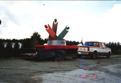
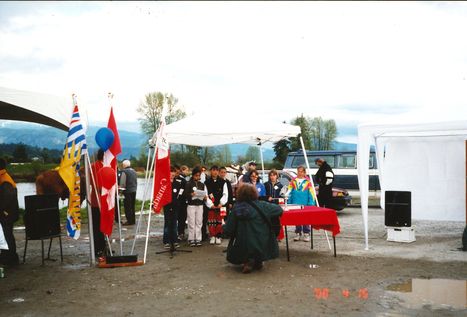
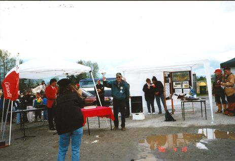
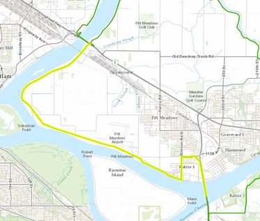
These three photographs were shot at the Trans Canada Trail opening ceremonies at Harris Road in Pitt Meadows on April 15th, 2000. The Trans Canada Trail was developed over several years across Canada. The project was officially completed in the Millennium year. The ceremonies for the Pitt Meadows part of the trail took place at Harris Road on April 15, 2000. The first photograph is showing the Trans Canada Trail logo/insignia being towed on a trailer behind a pickup truck (it would eventually be mounted in Victoria). The second and third photograph features the celebration during the opening ceremony. The last photograph is a screenshot from the greattrail.ca website showing the trail in Pitt Meadows.
The Great Trail website (greattrail.ca) also features this blurb about the trail in Pitt Meadows: “The Pitt River Greenway follows the Fraser and Pitt River dykes, offering excellent opportunities for walking, cycling and bird watching. Enjoy beautiful views of mountains, rivers and working farmland. Watch for wildlife including seal, muskrat, osprey, hawks and ducks. The trails at Harris Landing are semi-firm fine gravel trails that are at least 1.5 m wide. There is a steep slope (10%) from the parking lot down to the pass accessing the trails. The main trail at Harris landing is 900 m long. The Dyke Trail surface has loose gravel in some sections and is at least 3 m wide. The section from Harris Landing to the industrial area is 3 km long and the section from the industrial area to the Ferry Slip Landing is 5.8 km. Courtesy of Metro Vancouver.”
Details:
Latitude: 49.2046260243740
Longitude: -122.69096471086
Direct Link: https://www.pittmeadowsmuseum.com/locations/trans-canada-trail


