Peat Plant
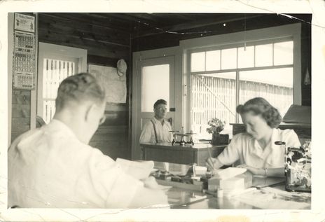
This photograph features three workers inside an office at the Peat Plant off Ford Road. The woman is most likely Frances Stevens (nee: Park) who was employed at the Plant. The following is from Edith McDermotts Historical Story of Pitt Meadows: “Pioneer Peat, established June 29, 1919 by Moncreiff and Vistaunet, was the first industry in Pitt Meadows. They built a large factory 40’x60’ by 40’ high into which a peat dryer was built which wasn’t very effective as it cost as much as a bale of peat was worth to dry it. So, before Christmas of 1930 the firm closed and the buildings lay idle until 1933. In March of 1933 Premier Peat Products (having been renamed) again opened the factory but by the end of three months it was again closed. In February of 1934 Alouette Peat Products which had previously operated on Harris Road North, bought the land and started up business … In July of 1940 the factory, sheds and officed burned but all the records were saved. Only the two houses remained. The owners, Nootbaar and Taylor, the latter J.H. Taylor of the Taylor Milling Company of Los Angeles, were able after some difficulty to collect the full insurance and so were in business again. During the war from 1942 on, peat from this factory was shipped to Las Vegas, Nevada, for use in the war effort. In time Las Vegas discovered that water could do the same job they were using peat for, so that market was lost. Peat sales were very slow during the war. Each year between 1934-1939 as many as 150 people worked at the harvesting of the peat. Fifty to 60 people worked regularly at the digging of peat, as piece work, McMyn Truck Line hauling from Alouette Peat during the year. This helped many during depression years. In 1948, because of the flood, no peat was dug but in 1949 work continued as usual. It was customary to dig enough peat to make 100,000 bales which was enough for the year’s sales. In 1949 the firm sold to Coast Peat of Byrnes Road, South Burnaby, as their plant had been destroyed by fire and they did not wish to rebuild there.” Once the peat business dried up, blueberry farms utilized the land.
Details:
Latitude: 49.2228644844735
Longitude: -122.72023288536
Direct Link: https://www.pittmeadowsmuseum.com/locations/peat-plant