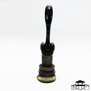
Hal Menzies Ltd. Embossing Seal
This artifact is an embossing seal. This seal was for “Hal Menzies Ltd.” William Henry Menzies and his first wife, Mary arrived in the Pitt Meadows/Maple Ridge area in 1891, living first at the Codd Island flats and then at McKenney Creek. By 1898 the family had homesteaded on 160 acres of land on what we now call Sheridan Hill but has since that time also been known as Menzies’ Mountain. When they arrived, they built a log cabin for their home but sometime before 1911 they replaced the cabin with a wood-framed house and that house remains on the site to this day and is a designated heritage building. William and Mary had several children with the most written about in our local history being William Halbert (Hal) Menzies, Maple Ridge’s first realtor. In 1910, Hal along with Donald Martyn and Angus McIver built a small office on Front and Ontario Street in Port Haney to establish their real estate business. When Martyn enlisted in the First World War, their business “Menzies and Martyn Real Estate” dissolved and was taken over completely by Menzies. In 1914, Hal married Ethel Best, a local resident. Hal Menzies had several of his own children and one of these, Wilma Robinson (nee: Menzies) was the last of the family to reside on what was left of the original homestead, having returned there in 1960, until her death in late 2012. Much of the acreage that Mrs. Robinson lived on was donated to the City of Pitt Meadows to be used as a park, and, as such should remain protected for the enjoyment of the community and for the protection of wildlife in the area.
Details:
Latitude: 49.2719807920742
Longitude: -122.66681775998
Direct Link: https://www.pittmeadowsmuseum.com/locations/hal-menzies-ltd-embossing-seal