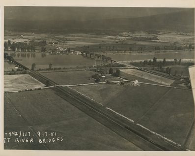
Aerial from July 9th 1951
This image is a sepia toned oblique aerial image looking north-west showing farmland, C.P.R. tracks, Lougheed Highway, Kennedy Road, Pitt River and the two bridges (C.P.R. and 1915 auto span) taken on July 9th 1951! It’s interesting to see how developed Pitt Meadows has gotten when you compare this 1950s photograph to today! That quiet highway is now a bustling roadway that thousands travel on every day!
Details:
Latitude: 49.2456838282639
Longitude: -122.72473680289
Direct Link: https://www.pittmeadowsmuseum.com/locations/aerial-from-july-9th-1951