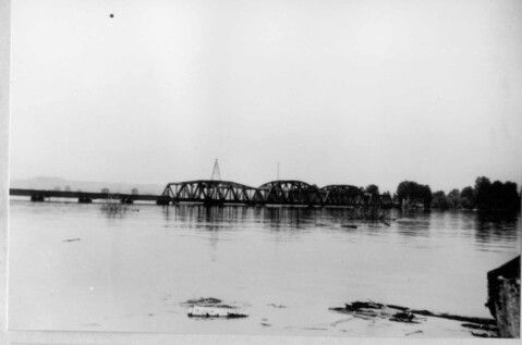
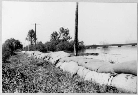
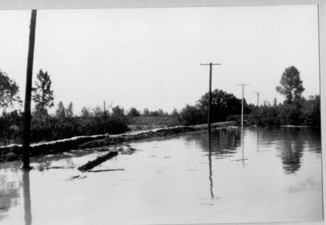
{"STATUS":"SUCCESS","ID":"271","LATITUDE":"49.2393245452112","LONGITUDE":"-122.74359640619","TYPE":"locations-mark","NAME":"1948 Flood","CONTENT":"The first image shows the C.P.R. bridge over the Pitt River, the second image shows sand bags and a distant bridge, and the third image shows sand bags and telephone poles. All the images show some of the damage caused by the flood. In 1948 the earthen dyking system that protected Pitt Meadows' lowlands was about 25 miles (40 kilometers) long and was built in a u-shape along the Alouette, Pitt, and Fraser Rivers. Disaster struck on May 24 \"following days of exceptionally warm weather, the north sector of the dike along the Alouette suddenly gave way and in a very short time 7,000 acres of land were under water. Harold Sutton [reeve] and his council, took charge and farmer evacuated all their cattle and householders moved to higher ground in the area or to other parts. The Community Hall became a centre for a Flood Fighter Organization. Constable Kelly Irving, of the B.C. Police, helped to organize the corps. Special telephone service was made available. The army and navy were sent to help, and fortification of the other dykes was given a tremendous spur. The whole countryside was readied to help save the rest of the area.\" (Historical Story of Pitt Meadows, by the Canadian Confederation Centennial Committee of Pitt Meadows, 1967) Following these floods there became greater demand to create preventative measures against future floods. This resulted in increased dyking, flood boxes, and pump stations to protect communities.","SEO_LINK":"1948-flood","VIDEO_LINK":"' frameborder='0' allowfullscreen>
Welcome to the Pitt Meadows Museum and Archive's Memories Mapping Project!
Click on the map to add your history or explore what others have left.
This project funded in part by: Government of British Columbia BC | Canada 150 Grants